 Figure 1. Example of the 2000 Land Cover Classification for the Niobrara River Watershed
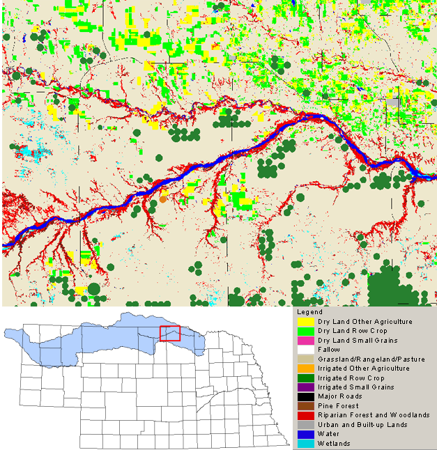
Principal Investigators: Patti Dappen; James Merchant, CALMIT, University of Nebraska-Lincoln.
Introduction: The Niobrara River watershed covers a large area in northern Nebraska, and neighboring parts of South Dakota and Wyoming, and is an important component of statewide natural resources management. Under ongoing agreements with the U.S. Bureau of Reclamation (BoR), the Nebraska Game and Parks Commission are charged with the development of management plans for various BoR projects in the Niobrara River watershed in Nebraska. A detailed delineation of land use and land cover patterns was needed in order to define and implement effective management strategies.
Methods: This project involved integrating remote sensing, spatial, and field data analysis to provide a map of land cover in the Niobrara River Watershed for the year 2000. Multi-date Landsat-7 Enhanced Thematic Mapper (ETM+) satellite imagery was used to generate this map. Imagery was selected to represent summer and fall growing conditions, with cloud coverage dictating specific date selection.
Image Classification: An unsupervised classification was performed on the multi-date imagery. After running the classification algorithm the output clusters were initially labeled based on their spatial, spectral and temporal characteristics. Each cluster was assigned to one of the target land cover classes using current ancillary data. Field data for crops were obtained from USDA Farm Service Agency (FSA) records. Irrigated cropland areas (center pivots) were identified using the 2000 Landsat 7 ETM+ data. The National Wetland Inventory was incorporated for wetland identification. Urban areas were defined using 2000 U.S. Bureau of the Census Topologically Integrated Geographic Encoding and Referencing system (TIGER) data and other information was gathered from 1993 USGS Digital Orthophoto Quarter Quadrangles. In all, 14 different land cover classes were identified.
Project Results: The Niobrara River Watershed land cover classification are presented in the 2005 Final Report for the State of Nebraska Department of Natural Resources.
Funding for this project was provided through grants from the U.S. Bureau of Reclamation and the Nebraska Game and Parks Commission, and supported by imagery from CALMIT.
