Remote Sensing: A new way to see our world
Remote sensing allows us to look more deeply into the workings of the world around us, and allows us to assess vegetation cover, productivity, and health. With emerging methods, we can detect plant stress, evaluate hydrological status, and assess biodiversity. Combined with geographic information systems (GIS), remote sensing allows us to understand spatial and temporal patterns across large regions.
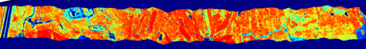
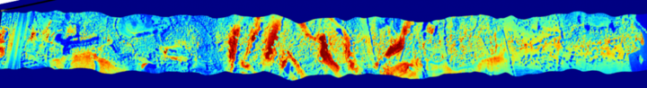
The images below are examples of how remote sensing helps us understand more about our world. The imagery shows Mahoney State Park (east of Lincoln, NE) three ways: 1) true-color, 2) NDVI (Normalized Difference Vegetation Index), a greenness index, and 3) SIF (Solar-Induced Fluorescence) in the oxygen A band, a measure of photosynthetic activity.
CALMIT uses different types of remote sensing instruments and methods to highlight plant productivity, stress, diversity and other important ecosystem traits and functions.

What does the Remote Sensing Imagery tell us?
Using a rainbow color scheme (high values in red, low values in blue) the imagery allows you to visualize different expressions of the data from our imaging fluorometer (IBIS). True-color imagery resembles human vision, NDVI imagery represents the “greenness” of the landscape, and SIF imagery depicts photosynthetic activity.
GPS and GIS
Since most remote sensing data describe fluorescence or reflectance properties of earth's features, Global Positioning Systems (GPS) measurements are used to provide exact locations in space for each datapoint. Geographical Information Systems (GIS) process these data in combination with other data to identify spatial and temporal trends in productivity, vegetation health, drought, land-use/land-cover change, and much more. CALMIT researchers have long been at the forefront in GPS and GIS tool development, starting with some of the first aerial imagery ever used to study landscapes (see our History page). The Center is recognized world-wide for its leadership in advanced land management and information technology techniques and research.
Footer