Research questions:
How can Earth observations improve our understanding of drought and the underlying hydrologic components related to this climatic extreme?
The suite of new satellite observations and tools that have emerged over the past decade allow evapotranspiration, precipitation, soil moisture, and vegetation health to be analyzed and monitored, providing a more comprehensive view of drought conditions.
What is the role and response of climate-vegetation-water interactions across the landscape to changing environment conditions and how does it affect agricultural and natural resource sustainability?
Drought is a complex, multi-faceted natural hazard. An effective response requires many types of information collected at various spatial and temporal scales. Satellite remote sensing can fill in the information gaps of traditional field observations, providing a more complete view of drought dynamics.
CALMIT researchers monitor and model the flow of water through natural and human-dominated landscapes to understand ecosystem function and to improve water use efficiency in food production. Our research is highly interdisciplinary, combining ecology, hydrology, agronomy, and geophysics.
Advancing the Cosmic-ray Neutron Method for Real-time Mobile Soil Moisture Mapping

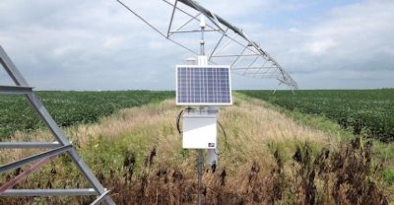
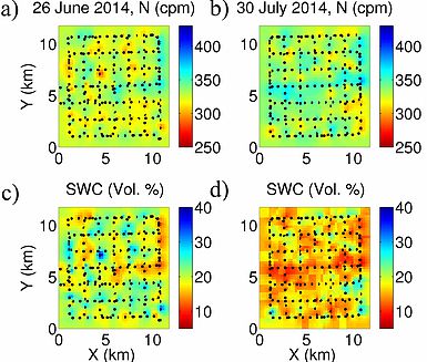
The long-term goal of this project is to develop the cosmic-ray neutron method for real-time mobile soil moisture mapping capabilities and to advance our understanding of the petrophysical transform, which converts the measured property (the intensity of low-energy neutrons) into the variable of interest (the area-average soil moisture). This research will also assess the potential of using remote sensing products to estimate the required local ancillary information for the petrophysical transform as opposed to the current practice of local direct sampling.
Investigators: Trenton Franz (University of Nebraska-Lincoln), Hydroinnova LLC, and Quaesta Instruments
Funding: DOD CRREL ($50,000, 2014-2015)
Pastoralism in Transition: Linking Localized Interactions and System Behaviors to Evaluate Social-Ecological Vulnerability

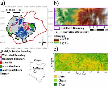
Drylands cover 40% of the continent of Africa, and are the basis for traditional pastoralist social ecological systems, in which societies have adapted to rely heavily or entirely on livestock production fortheir livelihoods in harsh and variable environments. Modernity has brought drastic political, social andland use changes, as well as unprecedented population growth, land degradation and more frequent droughts that decimate herds. Here the project team will employ complex adaptive system approaches to evaluate emerging patterns of vulnerability in two pastoralist communities in Kenya which have begun to diversify into maize agriculture alongside their struggling livestock-based livelihood system. We will adopt approaches to investigate how mixed land use affects the sensitivity of range productivity to drought and shifting grazing pressures; how composition and inequities in household livestock assets create differential patterns of risk exposure associated with entry into agriculture; and how evolving landuse institutions affect the coping capacity and resilience at individual and collective scales.
Investigators: Elizabeth King (UGA) and Laura German (UGA) (Franz consultant from UNL)
Funding: NSF Dynamics of Coupled Natural and Human Systems ($249,000, 2013-2015
Transcending heterogeneity: towards improved soil moisture scaling laws

In order to feed the growing world population by 2050, the FAO estimates a needed increase of 70% in cereal grains, placing a greater demand on dwindling water resources. Irrigation agriculture accounts for 40% of global food production, yet it is estimated that 60% of the 2,500 trillion liters of water used globally for agriculture each year is wasted through inadequate water conservation, distribution losses, and inappropriate irrigation times and rates. A salient solution is to irrigate only when and where water is needed, but a fundamental cause of excess water use is our inability to quantify soil moisture at the application scales where management decisions are made. Our limited knowledge of how soil moisture is organized across scales not only hampers our ability to better manage agricultural water efficiency but is also a fundamental question in hydrology. The long-term goal is to understand how soil moisture is organized across scales. The goal of this project is to further our understanding of how soil moisture is organized at intermediate scales where water management decisions are made but that have been largely underrepresented due to technologic and practical limitations. To overcome these limitations, the team will incorporate a suite of nested hydrogeophysical observations with different measurement areas/volumes and focus our observations in agricultural irrigation settings, which offer an ideal experimental setting.
Investigators: Trenton Franz (UNL) and Derek Heeren (UNL)
Funding: NSF Hydrologic Sciences (In Review)
Relevant Publications
Soil moisture scaling:
- Franz, T. E., Wang, T. J., Avery, W., Finkenbiner, C., & Brocca, L. (2015). Combined analysis of soil moisture measurements from roving and fixed cosmic ray neutron probes for multiscale real-time monitoring. Geophysical Research Letters, 42(9), 3389-3396.
Recharge estimates across the state using soil moisture monitoring networks:
- Wang, T. J., Franz, T. E., Yue, W. F., Szilagyi, J., Zlotnik, V. A., You, J. S., et al. (2016). Feasibility analysis of using inverse modeling for estimating natural groundwater recharge from a large-scale soil moisture monitoring network. Journal of Hydrology, 533, 250-265.
Irrigation scheduling routines in Western Nebraska and the effect of different technologies for reducing groundwater pumping:
Gibson, J., Franz, T., Wang, T., & Eisenhauer, D. (2017). A case study of field-scale maize irrigation patterns in Western Nebraska: Implications to water managers and recommendations for hyper-resolution land surface modelling. Hydrology and Earth System Sciences Discussions, in press.
CALMIT Partners for Hydrology, Drought, Soil Moisture Research
Federal
USGS Earth Resources Observation and Science (EROS) Center
USDA Agricultural Research Service (ARS) Hydrological Remote Sensing Lab (HRSL)
NASA Goddard Space Flight Center (GSFC) Hydrological Science Laboratory
NASA Jet Propulsion Laboratory (JPL) Terrestrial Hydrology Group
NOAA National Integrated Drought Information System (NIDIS)
University
National Drought Mitigation Center (NDMC), University of Nebraska-Lincoln
Daugherty Water for Food Institute (DWFI), University of Nebraska
University of Maryland-College Park; Earth System Science Interdisciplinary Center (ESSIC)
University of California-Santa Barbara (UCSB); Climate Hazards Group (CHG)
University of Nevada-Reno; Laboratory for Conservation Biogeography
University of Wisconsin-Madison; Cooperative Institute for Meteorological Satellite Studies
John Hopkins University Department of Earth and Planetary Sciences
University of Alabama-Huntsville; National Space Science and Technology Center (NSSTC)

